Calculate Area on Map Online
Find the land area of a shape you draw on a free online map
Do you want to know the area of your plot of land, your agricultural land area or the area of your rooftop in square feet, square meters, square yards, square kilometers, square miles or acres?
Simply draw the area on our Free Land Area Calculator Map tool. It will provide the measured area in multiple units.
Our free Land Area Calculator Map tool makes it easy to use. This Square Footage Calculator on Map is very easy to use.
Users Who Can Benefit from This Tool
Salient Features
Area calculator – Find the area of a shape you draw on free opensource webmap with Openstreet Maps. This free webgis tools allows you to calculate area of your desired location on web map using upto date OSM data in variety of units. Square Feet: This tool allows users to draw a shape and instantly see its area in square feet. Square Meter: By default it calculates area of the drawn polygon in square meters. Convenient drawing tool will make it easy to calculate area in square meters on web map. Square Yards: As the area has been calculated in square meters, Using unit conversion, you can easily calculate square yards by using following conversion formula. Square yards = Square meters × 1.19599
Example 1: Rooftop Area Calculation for Solar Panels Installation
Let’s suppose you are a home owner living in San Diego, California. You are interested in clean energy for your home. You want to install solar panels on your rooftop to reduce the electricity bill and to have environment friendly electricity resource. Before contacting the contractor you can estimate the available area on your rooftop by using this tool and can estimate the solar energy potential on your rooftop.
Example 2: Estimating Farm Size for Crop Planning
Imagine you have an agricultural land in lowa near Ames. You are preparing for upcoming season. This app will help you to estimate the size of each section of your farmland to plan how much seed and fertilizer is required. Instead of using traditional manual measurement techniques or complex GIS software that are designed for GIS experts, you ca use this Land Area Calculator. Detailed user guide is bellow.
User Guide: How to use this free web mapping tool to calculate area on map?
Locate the Address/ Zip Code / Current User Location:
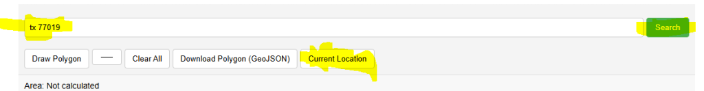
There are 3 ways to find the address on web map, 1- enter postal address in search bar and press search. 2- enter postal code or zip code in search bar and press search, 3- press current Location button and allow browser to get your current geo location. All these 3 options will zoom the map to desired location.
Choose Shape Color:
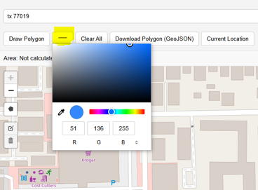
Select the color for shape that will be drawn on map to calculate the area from color pallet. It is very useful when user will draw multiple polygons or need to match the color theme.
Draw Polygon
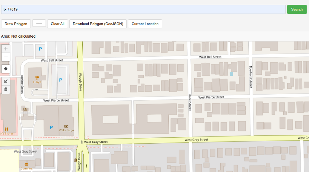
After selecting a color, click the ‘Draw Polygon’ button to activate drawing mode, this will change the mouse cursor to crosshair type. There are 2 ways to draw a shape to calculate area on map, first method already described and second one is on left hand side of the webgis application interface showing a small grey color polygon.
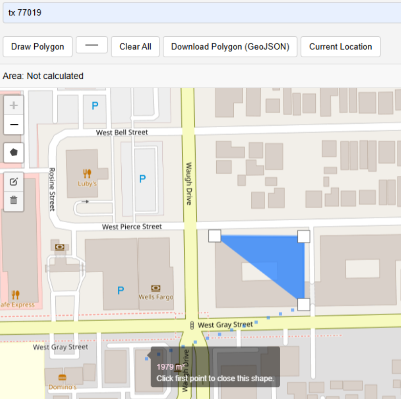
Activating the draw polygon on map mode will enable you to draw any shape on map of your area of interest. Simply zoom to the location where you want to calculate the area on map and click first node and by clicking the multiple nodes will cover the entire area of interest.
The entire area of interest is now enclosed within the drawn shape that you just added to map to calculate the area on map using this free mapping application. You can finish the sketch after clicking again on the very first point.
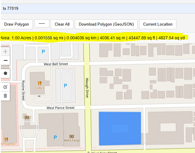
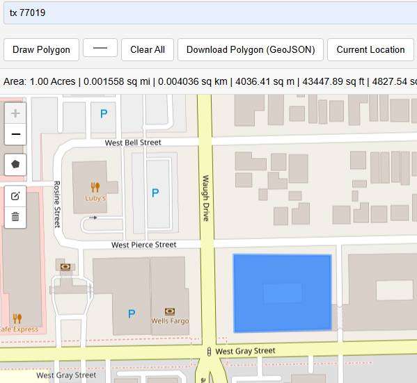
Once the polygon sketch is complete, the nodes will disappear and you will have a clear polygon and area summary will be displayed on top under the toolbar menu. In this example the values will be: Area: 1.00 Acres | 0.001558 sq mi (Square Miles) | 0.004036 sq km (Square Kilometers) | 4036.41 sq m (Square Meters)| 43447.89 sq ft (Square feet)| 4827.54 sq yd (Square Yards)
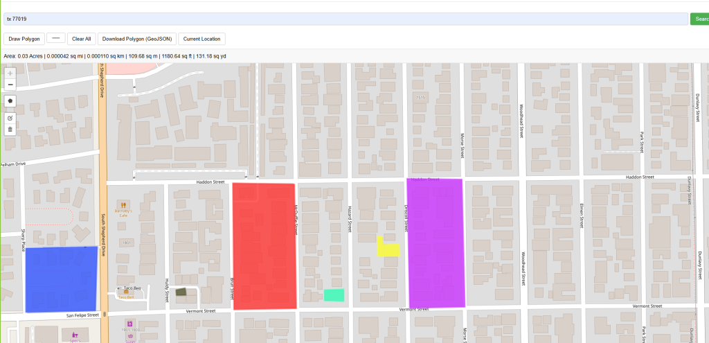
Multiple polygons can be added to the map in different colors of your choice. Summary section of area will show cumulative area for all polygons.
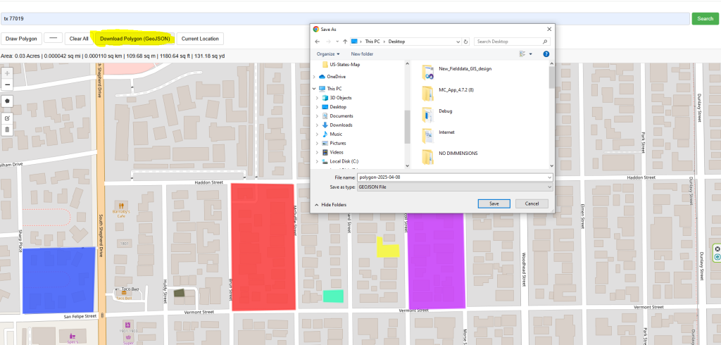
All polygons can be downloaded in GeoJSON format and used in popular GIS software like Esri ArcMap, ArcGIS Pro, QGIS, Google Earth etc.
Map Tools Brief Description
-
Radius Map Online – Measure Radius on Map :
Radius Map Tool is a very simple easy to use web map tool. With the help of this tool, you can draw a circle of your desired radius on map at given location. You can easily move and edit the circle on map by changing its color, radius and location. You can download the map as jpg.
-
Calculate Area on Map Online- Land Area Calculator Map:
Area Calculator on map is a free area map tool. This area calculator tool using web map allows you to find out the area in multiple units that is enclosed inside a closed polyline overlaid on a map. You can also download the data in geojson format.
-
Map Distance Finder - Driving & Straight Distance Between 2 Locations:
Distance Calculator on map is a very intuitive& simple free GIS web tool to calculate distance between two locations. It provides street or driving distance as well as straight distance. You can also download route data in the form of geoJSON to use on any GIS software.
-
Elevation / Altitude Finder By Address or Current Location:
Get your current elevation on map using this free online web map application. Just locate yourself on map and get the altitude of specific point. You will get elevation using 90 meter resolution dataset. It means accuracy of the elevation is approximation under 90×90 meters.
-
Zip Code Lookup by Address - Find a Post Code:
To find a zip code (or postal code) for your current location or a specific address, you can use this free tool to mark your position on map and find postcode on single click. Worldwide postal code finder for any address on map makes your life easier.
-
EV Charger Finder - Find Electric Car Charging Stations on Map:
Nearby EV charging station finder on map within United States and get google maps driving directions. This tool will allow you to search street address to find nearest charging port of required location. You can also enter the coordinates or you can use your current geographic location.
-
What is My Current Time Zone - Time Zone Map:
It provides your current GMT time zone, current local time, address date and coordinates worldwide. You can search your address or can use your GPS location. Retrieved information about the time zone can easily be shared on whatsapp.
-
GPX Data Viewer Online - View Hiking, Cycling, Running Data on Map:
Simple user friendly web mapping application to find time zone on map by simply searching the address, postal code, geographic coordinates. You can also search for current time zone by just click my location on map. Click on map and you will be provided detailed information about your current time zone.
-
Shapefile Viewer Online - View GIS Data in .shp Format:
Want to view your GIS data in Esri Shapefile .shp format on map online? Use our shp viewer free application tool to display your shp file format data online. Map can also be exported using this shapefile viewer online application.
-
GPX to GeoJSON Converter
Do you need to convert your GPS data stored in GPX format to well known GeoJSON data. This free web tool will do this job for you. Just upload data, convert and download the required format.
-
KML Online Viewer - Visualize .kml .kmz Data on Map Online
Web Application to view KML, KMZ files on street map and satellite image. View and explore KML and KMZ files online. Fast, free KML viewer shows your placemarks, paths.
-
Coordinates Plotter - Plot Latitude and Longitude on Map Bulk CSV
This online map application provides you with an interactive map made with your own geographic data in CSV file format.
-
Geotag Photos for Free - Batch Editing
Batch-upload up to 10 photos at once, edit EXIF metadata and geotag each image individually in just a few clicks, then export the updated files as high-quality JPEGs.
-
True Size of Countries
The world as it actually is, not just how it’s drawn. How big is your country? Drag it to find out. True Scale. Real Geography. No Distortions.