Nearest Electric Car Charging Stations Finder on Map in United States - Get Directions on Google Maps
Are you looking for nearest EV charging stations? Use this electric car charging stations finder on map
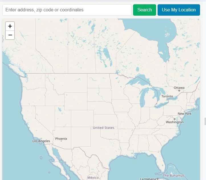
EV charging station finder application is a free web map tool that provides nearest ev charging stations’ location within United States. It also provides an option to get google map driving directions from selected position. Address zip code or coordinates can be searched to get the location on map and find nearest ev charging stations. This ev charger finder app can also get your current location and suggest nearest electric vehicle charging station location.
This application will find nearby ev charging station only in United States. EV charging nearby is our daily question. Using this free online web mapping application you can answer the question ev charging stations near me? by just entering your address or using your current GPS location using your mobile phone.
This electric car charging stations mapping tool will suggest nearby ev chargers with respect to your entered zip code or your current location. You can select the electric car charging point on map, click on point and it will show the option to get directions on google maps.
Key Features of Electric Car Charging Points Map Application:
User Guide: Step by Step
This user guide will help you to understand the functionalities of nearby ev charging station finder application on map.
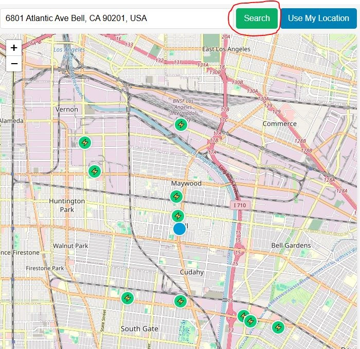
Step 1: Search by Location:
On top most row of application there is a search bar to enter complete street address, zip code / postal code or geographic coordinates in the form of latitude and longitude. Press search button in green color and map will zoom to searched address or location. Map will display nearby ev chargers to entered location.
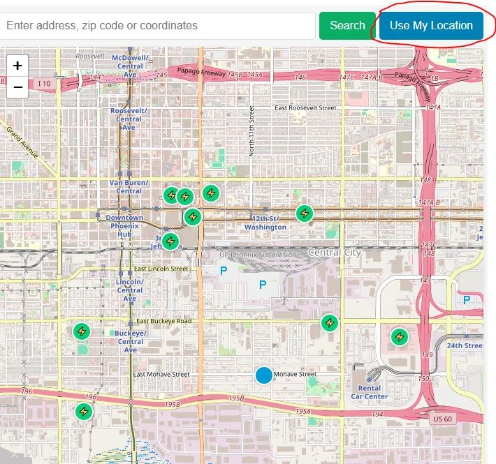
Step 1-1: Search by My Current Location to Find EV Charging Stations near me:
On top most row at right corner there is a button labeled “Use My Location”. Click or tap on use my location, browser will ask you to allow to get your current location. When you will allow your browser or mobile phone to get your geographic location then map will be zoomed to your current location. Here is now the answer to your question: EV Charging Stations near me.
Step 2: Click or Tap on EV Charging Points and Get Information
Now you will have electric vehicle charging point locations on map near your current location. Big blue dot on web map is showing your current location and Green circles with electricity sign are showing nearby electric cars charging points. Click or tap on any desired ev charger location. A popup with required information will appear.
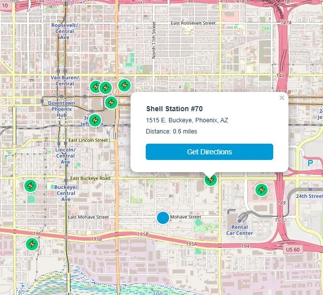
Popup window will display address and zip code of electric car charging station and distance from your current location. In this example distance to Shell Station #70 is 0.6 miles from current user location.
Step 3: Get Directions to Nearest EV Charging Point
Inside popup window there is a button labeled “Get Direction”, When you will click this button it will redirect to Google Maps in new browser tab. Now you can get driving direction to selected charging station from your current location on google maps.
Frequently Asked Questions:
Ans: This is very easy to use. Simply enter the address or zip code in search bar or click on “Use My Location”. Map will be zoomed to the location and will show nearest charging stations. click on any charging station and click on get directions.
Ans:Currently this tool can only be used in United States. In future, we will add more countries to this.
Ans: Simply click on “Use My Location” and allow browser to read your geographic location.
Ans: When you click on the EV station marker on map, the popup will show address and zip code , distance from entered location and option to get direction.
Open Source Resources
Map Tools Brief Description
-
Radius Map Online – Measure Radius on Map :
Radius Map Tool is a very simple easy to use web map tool. With the help of this tool, you can draw a circle of your desired radius on map at given location. You can easily move and edit the circle on map by changing its color, radius and location. You can download the map as jpg.
-
Calculate Area on Map Online- Land Area Calculator Map:
Area Calculator on map is a free area map tool. This area calculator tool using web map allows you to find out the area in multiple units that is enclosed inside a closed polyline overlaid on a map. You can also download the data in geojson format.
-
Map Distance Finder - Driving & Straight Distance Between 2 Locations:
Distance Calculator on map is a very intuitive& simple free GIS web tool to calculate distance between two locations. It provides street or driving distance as well as straight distance. You can also download route data in the form of geoJSON to use on any GIS software.
-
Elevation / Altitude Finder By Address or Current Location:
Get your current elevation on map using this free online web map application. Just locate yourself on map and get the altitude of specific point. You will get elevation using 90 meter resolution dataset. It means accuracy of the elevation is approximation under 90×90 meters.
-
Zip Code Lookup by Address - Find a Post Code:
To find a zip code (or postal code) for your current location or a specific address, you can use this free tool to mark your position on map and find postcode on single click. Worldwide postal code finder for any address on map makes your life easier.
-
EV Charger Finder - Find Electric Car Charging Stations on Map:
Nearby EV charging station finder on map within United States and get google maps driving directions. This tool will allow you to search street address to find nearest charging port of required location. You can also enter the coordinates or you can use your current geographic location.
-
What is My Current Time Zone - Time Zone Map:
It provides your current GMT time zone, current local time, address date and coordinates worldwide. You can search your address or can use your GPS location. Retrieved information about the time zone can easily be shared on whatsapp.
-
GPX Data Viewer Online - View Hiking, Cycling, Running Data on Map:
Simple user friendly web mapping application to find time zone on map by simply searching the address, postal code, geographic coordinates. You can also search for current time zone by just click my location on map. Click on map and you will be provided detailed information about your current time zone.
-
Shapefile Viewer Online - View GIS Data in .shp Format:
Want to view your GIS data in Esri Shapefile .shp format on map online? Use our shp viewer free application tool to display your shp file format data online. Map can also be exported using this shapefile viewer online application.
-
GPX to GeoJSON Converter
Do you need to convert your GPS data stored in GPX format to well known GeoJSON data. This free web tool will do this job for you. Just upload data, convert and download the required format.
-
KML Online Viewer - Visualize .kml .kmz Data on Map Online
Web Application to view KML, KMZ files on street map and satellite image. View and explore KML and KMZ files online. Fast, free KML viewer shows your placemarks, paths.
-
Coordinates Plotter - Plot Latitude and Longitude on Map Bulk CSV
This online map application provides you with an interactive map made with your own geographic data in CSV file format.
-
Geotag Photos for Free - Batch Editing
Batch-upload up to 10 photos at once, edit EXIF metadata and geotag each image individually in just a few clicks, then export the updated files as high-quality JPEGs.
-
True Size of Countries
The world as it actually is, not just how it’s drawn. How big is your country? Drag it to find out. True Scale. Real Geography. No Distortions.