KML Viewer Online - .kml .kmz Data visualizer on Map
Curious to see your KML or KMZ data on an interactive map without any desktop software? Want to view kml file in web browser?
KML and KMZ file formats are used to store geographic data in the form of points, Lines, and Polygons. KML is the short form of Keyhole Markup Language and KMZ is zipped version of KML. It is XML based plain text format to represent the geographic data.
This geodata file format is widely used by Google mapping products like Google Earth and Google Maps. It is very lightweight text based geodata file format and used by professionals, researchers and students on daily bases.
We have developed a very simple, basic and intuitive .kml .kmz file viewer online free web tool using free resources and libraries with no proprietary software involved. Kmz Kml file viewer free web map application is very easy to use.
Key Features of KML Data Visualizer:
User Guide: How to View KML Data on Map? Step By Step
This free webgis tool is quite straight forward to use and can display your GIS data in .kml or .kmz file format in few clicks.
Step 1: Browse file location on local computer
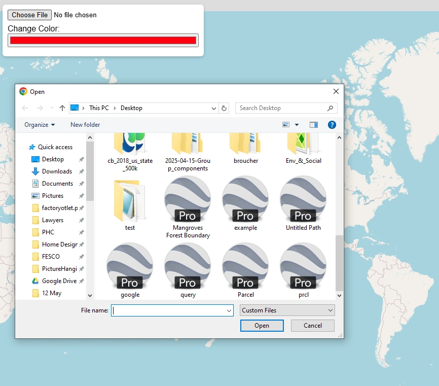
Click on choose file button. A file browser on your PC will be opened. Browse the kml file location and select. Now press open. File will be automatically loaded on map and map will be zoom to the extent of data.
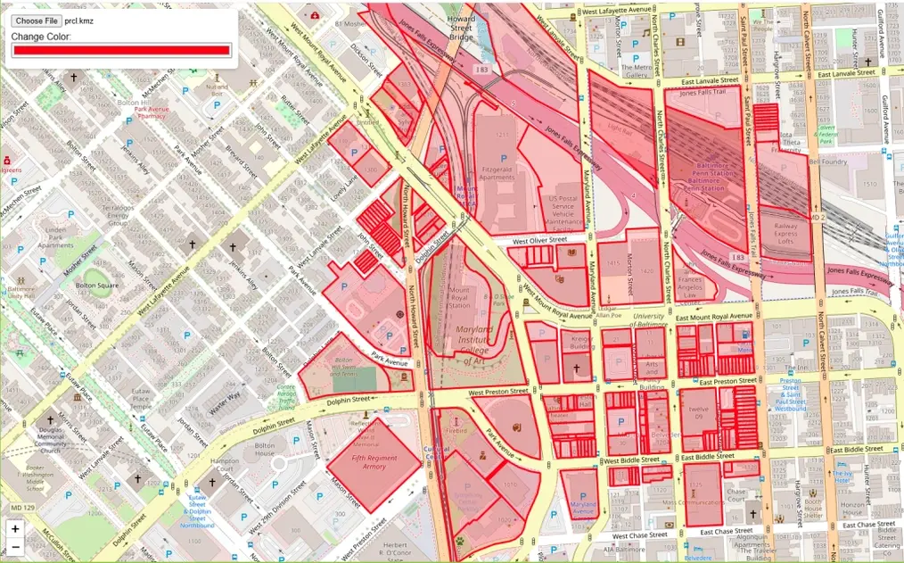
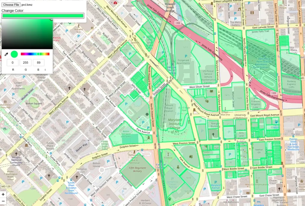
Step 2: Change The Colors of Map
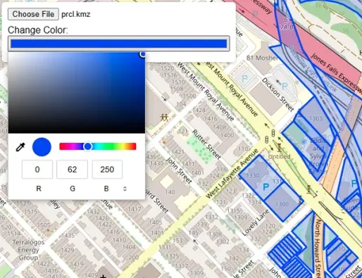
Once geodata is successfully loaded on map, now you can change the color of map. Click on color button a color picker will be opened. Choose the color and click on map.
Step 3: Change Basemap
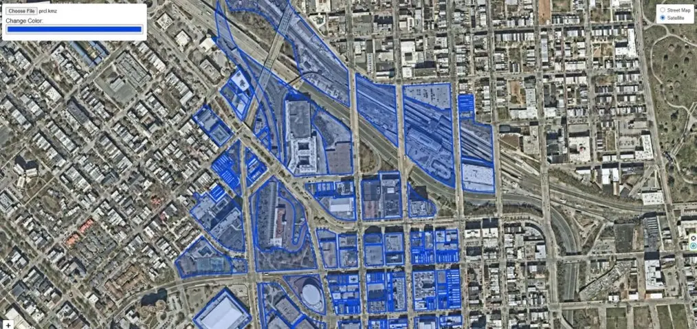
On upper right corner you can see a layer icon. Click on the button, it will show basemap switching options from streetmap to satellite.

Step 4: Click on Feature to Get Relevant Information in Popup Window
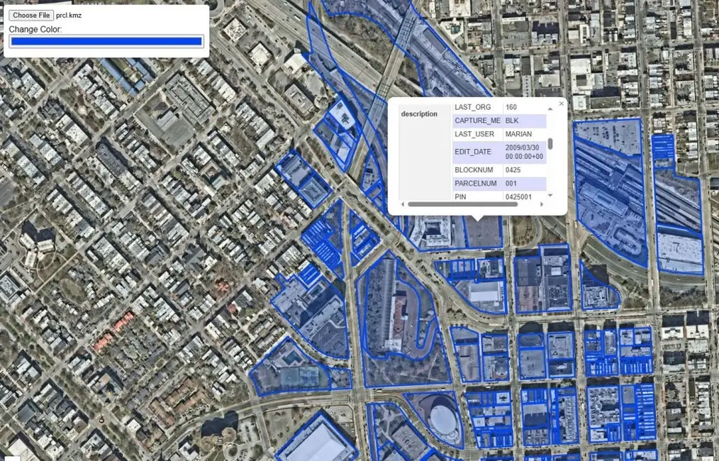
Click on any feature on map. It will show a popup information window with relevant information stored in the data.
A Brief History of the KML File
The KML (Keyhole Markup Language) file format was originally developed by Keyhole Inc. in the early 2000s as a way to display geographic data in the company’s 3D Earth visualization software, Keyhole Earth Viewer.
In 2004, Google acquired Keyhole Inc., rebranding the software as Google Earth. KML quickly became the standard format for sharing geographic information such as placemarks, paths, and polygons within Google Earth and later Google Maps.
Recognizing its growing importance, the Open Geospatial Consortium (OGC) officially adopted KML as an international standard in 2008, ensuring compatibility across multiple GIS and mapping platforms.
Today, KML—and its compressed version, KMZ—remain popular formats for sharing and visualizing geospatial data across the web, mobile apps, and desktop mapping software.
Key Differences Between KML and KMZ Files
Although KML and KMZ files are closely related, they serve slightly different purposes in how geographic data is stored and shared.
| Feature | KML File | KMZ File |
|---|---|---|
| Full Name | Keyhole Markup Language | Keyhole Markup Zipped |
| File Extension | .kml | .kmz |
| Format Type | Plain text (XML format) | Compressed (ZIP format) |
| Contents | Contains geographic data such as placemarks, paths, polygons, and styles | Contains one or more KML files plus related resources like images, icons, and overlays |
| File Size | Larger, since it’s uncompressed | Smaller and faster to share due to compression |
| Ease of Editing | Easily editable with any text editor | Must be unzipped to edit individual KML or image files |
| Best Use Case | For simple, lightweight maps or data sharing | For complete map packages that include multiple resources |
In short:
KML is a readable XML file describing map data, while KMZ is a compressed version of KML — ideal for sharing complex maps with linked files and media.
Open Source Resources
Map Tools Brief Description
-
Radius Map Online – Measure Radius on Map :
Radius Map Tool is a very simple easy to use web map tool. With the help of this tool, you can draw a circle of your desired radius on map at given location. You can easily move and edit the circle on map by changing its color, radius and location. You can download the map as jpg.
-
Calculate Area on Map Online- Land Area Calculator Map:
Area Calculator on map is a free area map tool. This area calculator tool using web map allows you to find out the area in multiple units that is enclosed inside a closed polyline overlaid on a map. You can also download the data in geojson format.
-
Map Distance Finder - Driving & Straight Distance Between 2 Locations:
Distance Calculator on map is a very intuitive& simple free GIS web tool to calculate distance between two locations. It provides street or driving distance as well as straight distance. You can also download route data in the form of geoJSON to use on any GIS software.
-
Elevation / Altitude Finder By Address or Current Location:
Get your current elevation on map using this free online web map application. Just locate yourself on map and get the altitude of specific point. You will get elevation using 90 meter resolution dataset. It means accuracy of the elevation is approximation under 90×90 meters.
-
Zip Code Lookup by Address - Find a Post Code:
To find a zip code (or postal code) for your current location or a specific address, you can use this free tool to mark your position on map and find postcode on single click. Worldwide postal code finder for any address on map makes your life easier.
-
EV Charger Finder - Find Electric Car Charging Stations on Map:
Nearby EV charging station finder on map within United States and get google maps driving directions. This tool will allow you to search street address to find nearest charging port of required location. You can also enter the coordinates or you can use your current geographic location.
-
What is My Current Time Zone - Time Zone Map:
It provides your current GMT time zone, current local time, address date and coordinates worldwide. You can search your address or can use your GPS location. Retrieved information about the time zone can easily be shared on whatsapp.
-
GPX Data Viewer Online - View Hiking, Cycling, Running Data on Map:
Simple user friendly web mapping application to find time zone on map by simply searching the address, postal code, geographic coordinates. You can also search for current time zone by just click my location on map. Click on map and you will be provided detailed information about your current time zone.
-
Shapefile Viewer Online - View GIS Data in .shp Format:
Want to view your GIS data in Esri Shapefile .shp format on map online? Use our shp viewer free application tool to display your shp file format data online. Map can also be exported using this shapefile viewer online application.
-
GPX to GeoJSON Converter
Do you need to convert your GPS data stored in GPX format to well known GeoJSON data. This free web tool will do this job for you. Just upload data, convert and download the required format.
-
KML Online Viewer - Visualize .kml .kmz Data on Map Online
Web Application to view KML, KMZ files on street map and satellite image. View and explore KML and KMZ files online. Fast, free KML viewer shows your placemarks, paths.
-
Coordinates Plotter - Plot Latitude and Longitude on Map Bulk CSV
This online map application provides you with an interactive map made with your own geographic data in CSV file format.
-
Geotag Photos for Free - Batch Editing
Batch-upload up to 10 photos at once, edit EXIF metadata and geotag each image individually in just a few clicks, then export the updated files as high-quality JPEGs.
-
True Size of Countries
The world as it actually is, not just how it’s drawn. How big is your country? Drag it to find out. True Scale. Real Geography. No Distortions.